Hong Kong has no fewer than 261 islands! Many of them are still inhabited, but plenty are not – and these are great places to seek some peace and quiet, away from all the hustle-and-bustle of city life. Many of these islands are terrific for hiking. Some are easy to get to, others are more remote.
Some islands were once inhabited, but have now been abandoned as the communities have moved away in search of work and a more modern style of living – relics of the past offer a ghostly echo of those that once lived in such places.
Here are some of our favourite spots if you want to go island-hopping.
Lamma Island
Long held as a get-away for hippies, Lamma has a very different feel to it than many of the other places in Hong Kong. There is a welcome vibrancy to the place, and a peculiar type of laid-back charm it is impossible not to warm to.
Swathes of green pastures and rocky outcrops cut through the island, linking the two principal towns — Yung She Wan in the north and Sok Kwu Wan in the south together.
Some decent restaurants, quirky little shops and a few top beaches make the place all the more worth visiting.
Add to this the fact that the island is only a short hop from Central — a mere thirty minutes by ferry — and it is little wonder that so many expats end up calling this place their home.
Although Lamma has become a popular place to visit, you don’t get the sense that you have fallen into a tourist trap when you are here — restaurants have good food at decent prices.
There are nice walks all over Lamma, and many people descend on the island at weekends to do a spot of hiking. A particularly well-trodden path is the route between Yung She Wan and Sok Kwu Wan, which you can do in an hour (though put aside two if you want to take things at a more leisurely pace). Some of the best scenery lies just beyond Sok Kwu Wan in the south.
Cheung Chau
Cheung Chau is full of contrasts.
The first impression of the island is that it is a typically modern place, with big supermarket chains, fast-food outlets and branded shops that are not present on many of the other Outlying Islands.
But then walk to the other side of Cheung Chau and you will see quaint little villages, pleasant country walks and some run-down houses.
Cheung Chau is the busiest of the Outlying Islands, something that is noticeable from the moment you arrive: seafood restaurants crammed with diners and the beaches near the ferry pier crowded with bathers. But start exploring the island and you will quickly discover many backstreets and country lanes that are much emptier.
Perhaps the island’s most famous tradition is the annual bun festival, which takes place in either late April or early May.
Villagers dress themselves up as gods and parade through the streets to ward off evil spirits. No one is quite sure of when this tradition started, but it is thought to have begun in the 18th century, following a plague that devastated the small island. In order to counter the plague, fishermen built an effigy of Pak Tai, the Taoist god of the sea, to ward off the evil spirits.
The highlight of the festival is a ‘bun scrambling’ contest, which starts at midnight and sees competitors scramble up a bamboo tower covered with handmade buns.
Sharp Island
Sharp island (‘Kiu Tsui Chau’ in Cantonese) is a pretty little place. But due to its popularity and proximity to Sai Kung Town (only two kilometres away) it is often crowded.
The island is strewn with quartz rocks that are endearingly shaped like the local Cantonese pineapple bun. You won’t find these tasty-looking rocks anywhere else in the territory — they have been fashioned over millennia by the particular weather patterns that are prevalent in the area.
Aside from the impressive rock formations, the most distinctive feature of the island is the natural land-bridge (or tombolo) that links Sharp Island to the small islet of Kiu Tau. The tombolo was formed over centuries by the deposit of rocks and sand. You can walk along the land-bridge at low tide when the waters have retreated enough to reveal the tombolo — but don’t get cut off! Kiu Tau isn’t terribly big. If you walk to the top of it, you will get nice views over Hap Mun Bay and on a clear day you should be able to see as far as Clearwater Bay on the mainland.
Sharp Island is also a good place to snorkel. The surrounding rocky outcrops break up the ocean waves, so waters are generally quite calm.
Yim Tin Tsai
These days, the small island of Yim Tin Tsai, a 15-minute boat ride from Sai Kung Town, is virtually deserted. Records show that it no longer has a permanent settlement, but there are a handful of people who appear to have taken up residence here.
In its heyday, up to 1000 people may have lived on the island. The community would have survived on farming, fishing and salt-making (the island’s name, in fact, means ‘small salt field’). You can still see some of the old salt fields, which have now been converted to fish ponds.
The island comes alive during weekends, as droves of visitors and tourists flock to its shores.
There is only one main path on the island so there is no risk of getting lost.
As a reminder of the island’s Christian heritage, there are two churches here: an unnamed chapel, now in ruins, and Saint Joseph’s Chapel, which still functions as a church. Both churches are fairly close together. Just next to the ruins you will find a recent statue of Saint Joseph Freinademetz, who was an early Italian missionary to China.
It is fascinating to wander around the abandoned hakka homes and see how people used to live. The village has remained almost as it was, with houses still containing the belongings of their previous occupants (from radios, kitchen appliances and televisions to bed frames and crockery). In many of the houses, bats have now taken up residence.
Tap Mun
Tap Mun — which translates as ‘Grass Island’ — is another very picturesque island off the coast of Sai Kung, where the hundred or so people still living on the island enjoy a very laid-back way of life.
You don’t have to go back all that far to find a time when the island had a couple of thousand people dwelling within its perimeters. It even had a school — but this closed down in 2003 due to a dwindling population.
There is not all that much to the old fishing village, which is where ferries from the mainland will drop you off. Here you will find public toilet facilities and a few basic shops. Shop prices are a bit high, as is to be expected when you are in the middle of nowhere.
In the fisherman’s village, you can observe the locals hauling in their daily catch and drying out the fish and shrimp on whatever available surface they can find — a tradition that goes back hundreds of years.
Tap Mun is a popular place to come for camping, even though there is no designated campsite on the island.
The most iconic thing to see on the island is the balanced rock. The rock can be clearly seen from a distance as you approach and is so-called because it resembles two neatly stacked rocks. Some believe that these rocks gave the island its name, since they look like a stupa, balanced rocks that are used to mark the remains of Buddhist monks or nuns. Over the years, ‘stupa’ could have become ‘tap’.
There are three beaches on the island. Two of them are fairly rocky and not for everyone, whilst the third, located at the fishing village, is sandy. It’s not a great beach — small and often with some rubbish in the water — but its good enough for a quick cool down.
Tap Mun is also home to a trio of temples. These temples date back to the 18th century.
Something else worth visiting is the abandoned King Lam School on the hill above the village. It was built in 1957 and, when it closed in 2003, famously had only one pupil.
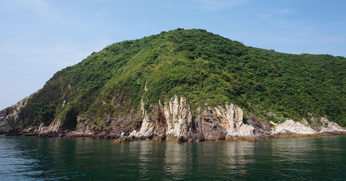
Tung Ping Chau
Tung Ping Chau is a remote and rather striking island in the far north-east of Hong Kong. It is actually closer to mainland China than to the rest of Hong Kong, so your mobile may switch to roaming and jump onto a network from the mainland (pay particular attention to any charges this might incur from your provider).
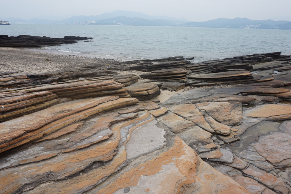
The island is formed from new sedimentary rock, resulting in a brightly coloured, multi-layered and exceptionally photogenic landscape. The island is in a protected marine park.
Ferries to the island only run during weekends and public holidays. There tend to be fewer people on the island on Saturdays.
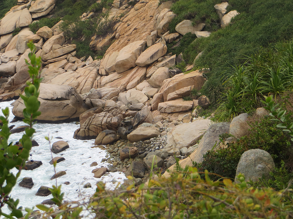
The island is excellent for hiking, because it brings together both rocky and sandy beaches, some excellent Cantonese eateries and stunning geological beauty. Walking conditions around the island are relatively easy. There are no major climbs and you can choose whether to walk on the beach or through the forest. There are public toilets scattered throughout the island, although they are less clean than those found in other spots in Hong Kong.
There are no shops on the island, although you will encounter the occasional vendor selling soft drinks, homemade bitter tea and homemade aloe vera juice (between 10 and 13 HKD each).
The island is a popular spot for birdwatching. You will be able to see a variety of migratory species and a number of native seabirds.
Some of the best-preserved coral in the whole of Hong Kong is also found here, so it’s a good spot for diving or snorkelling. The waters are generally crystal clear at most times of the year.
On the south-eastern tip of the island, at a place known as ‘Kang Lau Shek’, sit two vertical columns that resemble stacked slate. The columns are unique and have been formed over centuries of weather and sea erosion.
Lan Kwo Shui, also located in the southern part of the island, is a spectacular vertical cliff that runs along the coast. There are many caves carved into the cliff, but not all of them are easy to reach. The low-lying ones can only be reached on foot at low tide and when the sea is calm — but pay very careful attention to how fast the sea can come in!
To the south-west of the island is a bed of long thick rock with a triangular edge that some suggest looks like a dragon’s back extending into the sea. This area is called Lung Lok Shui.
A six-kilometre country trail loops around the island.
There are a handful of restaurants on the island, although most only open at weekends or during public holidays.
Po Toi
Just ten kilometres from Stanley is the small yet picturesque island of Po Toi.
It used to be home to more than 1000 people, but it’s population is declining and is now home to less than 200. The many aboandoned houses on the island give many of the neighbourhoods a rather eerie feel.
The island has become a popular day-trip destination, so expect it to get quite crowded at weekends, particularly when the sun is shining.
The island is a great place for a day’s walking. It is only 3.7 square kilometres in size and there is just a single path that loops around it in a figure-of-eight.
The full length of the walk takes about three hours, past Po Toi’s photogenic lighthouse, some dramatic and unusual rock formations and a few Bronze Age rock carvings. There is also a pagoda on a hilltop, offering some rewarding views of surrounding countryside.
Much of the walk is cross-country rather than on marked paths, with some of the time spent clambering over large rocks. When it rains, parts of the route can get fairly slippery, but at such spots there are ropes or railings to hold on to.
The walk is a circular route and well-signposted so it is difficult to get lost.
There is a famous seafood restaurant — Ming Kee — that is well-worth trying. Sometimes people come to the island just to eat here.